Peyre-Martine, the jewel of Montpellier's hinterland
A wide-ranging tour starting in the Buèges valley, "a little hidden gem in the Montpellier hinterland", which takes you to the luminous heights of the Séranne massif.

An exceptional site.
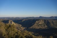
Whether you're looking at it straight on or from the heights of the Séranne cliffs, the Buèges is definitely the little-known nugget of the Hérault department. A rich, welcoming valley, vertical relief with a mountainous feel, a river full of surprises bathed in an enchanting atmosphere and, last but not least, charming villages full of character.
All the elements are in place for both public and sporting hikes. For walkers who don't want to follow the crowds, this is a place to discover during a stay in the Hérault.

Departure point : Saint-Jean-de-Buèges
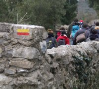
From the car park behind the church, take the cement track leading out of the village. At the fork in the road, take the track on the left between the low drystone walls.
Path on the right
At the calvary, take the path on the right. It winds upwards (with a view over the Buèges valley) and reaches the crest of the Séranne massif. After the box-tree-ringed meadow, walk along the barbed wire fence and continue along the wide track for 150 m.


An unforgettable panorama.
Leave the track, go left and pass under the power line. The path enters a boxwood undergrowth and gradually climbs to the summit of Peyre-Martine (782 m and its viewpoint).
Descend through the lapiaz (follow the signs) and reach the pass (cross) overlooking the Séranne cirque (GR® 74).

A break at the spring
Take the left-hand path down into the valley. Go through the hamlet of Méjanel, down the track to the left and reach the access car park to the Buèges spring (picnic area).

It's time to set off again.
Continue along the road, cross the D122 and turn left onto the path through the dolomites. Climb gradually through oak and heather vegetation to a fence on the ridge.

Massif de la Séranne
Cross the fence through the wicket gate and continue along the track on the left alongside the fence (viewpoint opposite over the Séranne massif). Continue along the ridge, then down the steep slope and, further on, through a small cedar wood (close the gates tightly).
Direction Saint-Jean-de-Buèges
Take the DFCI track on the left for 1.5 km, then the D122 on the left for 75 m and turn right onto a path through undergrowth. It descends and crosses a combe. Cross the D122, go through the gate and find the road below. On the right, it leads to Saint-Jean-de-Buèges.

Type : Pedestrian
Start: Saint-Jean-de Buèges
Length : 15 km
Time: 6 hours
Difference in altitude: 2062m

Pour en découvrir encore +


